

 to add an item to your Itinerary basket.


Book Tickets Online
About
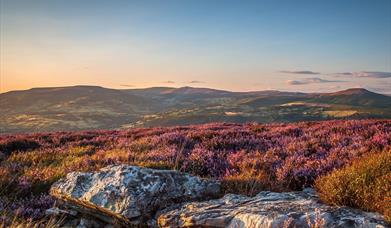
Grwyne Fawr Reservoir is a 2.5-mile uphill walk from the Blaen-y-Cwm/Mynydd Du car park. Look carefully and you might see wild ponies grazing among the gorse and take in views of the valley and the mighty conifers of the Mynydd Du forest in this remote area of the Black Mountains.
Walking to Grwyne Fawr Reservoir
There are two choices to make at the start of this walk. The first choice is to decide whether you want a very simple straight forward walk lasting just over an hour, on a clear track from the Mynydd Ddu car park (Grid ref:SO253285) up to the Grwyne Fawr dam and back again by retracing your steps, or whether you want a longer circular walk, lasting 4 to 5 hours depending on your chosen pace. The longer walk is only for the well shod! Waterproof boots and gaiters are essential. It's boggy on the tops!
If you decide to do the longer walk, choose which way round to do the walk: you can either start by walking up the valley, past the reservoir up to the very top of the scarp above some waterfalls at grid ref SO204327, crossing over to the trig point on Rhos Dirion at grid ref: SO211334 and returning back to the start by walking along the long elevated spine if the hill and cutting down to the valley bottom and the car park. The alternative is to start with the steep walk from the car park on to the top of the hill and return on the lower path past the reservoir and dam.
This description takes the former route, walking NE up the valley and past the reservoir and back along the tops.
The drive up the Grwyne Fawr valley is beautiful and the Grwyne Fawr reservoir is sign posted. The lanes are narrow and windy and Mynydd Ddu car park is at grid ref: SO253285 in the valley bottom.
The track leaves the car park at the far end and runs parallel with or follows the road for the first 200 meters or so before eventually leaving the road which follows the river up the valley to the foot of the dam. You do not want to follow the road. The track climbs gentle up and clings to the side of the valley and brings you to the top of the dam wall. Very soon after starting on the track it forks (see picture). Take the left of the two paths. The other is the path you will return to the car park on. It looks innocuous enough, but it is steep and winds up through the trees and in wet weather becomes a stream bed.
The track up to the dam is used by vehicles and off road motorbikes on rare occasions. It is clear and not too muddy, however, it can be wet under foot, especially after rain when the streams run across the road.
The views to the left are of Waun Fach, the highest point of the Black Mountains. On a sunny day the reservoir is a glorious sight and the story of how the dam was built and the industry of the area is compelling. At the reservoir wall you have a choice of two paths, each going through a five bar gate. Go through the right hand of the two gates and continue on the path above the reservoir. The valley gradually gets shallower as it rises, and the track deteriorates into a rocky path which can be very wet! The valley eventually levels out on to a broad peaty plateau which shows distinct marks of the damage by off road motorbikes and mountain bikers. Your path heads off to the right towards the trig point at the top of Rhos Dirion, but go as far as the gate through the fence, where the views down into the Wye valley open up at you feet. On a fine day the views are stunning and worth spending time taking in before heading back south east. Once at the gate take a compass bearing on the trig point on Rhos Dirion at grid ref: SO211334. Once at the trig point, turn right and take a compass bearing on Twyn Talycefn at grid ref SO222325.
The path is indistinct but the overall direction is obvious in clear weather. The compass heading stays the same all the way along this stretch. Offa's Dyke runs along the top of the ridge over to your left. Keep to the highest point of the ridge. Before the path rises up to Chwarel y Fan you need to take the path on the right down from the ridge to intersect with a forest gate at SO249294.
The exact point at which the path leaves the ridge is extremely unclear despite the map suggesting a clear bridle path. Perhaps from the back of a horse its clearer, but from a walker's perspective it is not at all clear and you need to make your decision. The cairns marked on the map are not all still there either. The first cairn as you come south east SO250303 is very small and you need to head off diagonally to the right at this point. Aim for the forestry plantation. The galvanised gate stands out well. The map again suggests a straight path down to the track leading to the car park. It's not! It's the most difficult bit of the walk and you need to be careful not to slip. The path follows a stream bed and twists a little before emerging briefly onto a forest road before plunging down to the right (there's a blue way marker). Once at the bottom the way to the car park is clear and you have completed the walk.
Book Tickets
Facilities
Routes
- Typical duration of route - 4-5 hours
Map & Directions
Road Directions
The Black Mountains lie within a triangle defined by the towns of Abergavenny in the southeast, Hay-on-Wye in the north and the village of Llangors in the west. Another 'gateway' town to the Black Mountains is Talgarth
Public Transport Directions
The nearest railway station is Abergavenny.


")

