

 to add an item to your Itinerary basket.


Book Tickets Online
About
This scenic circular walk takes you through the farming fields of Montgomery east, from the remnants of ridge and furrow farming from the middle ages to Boardyhall wood past Lymore lodge and current farm buildings.
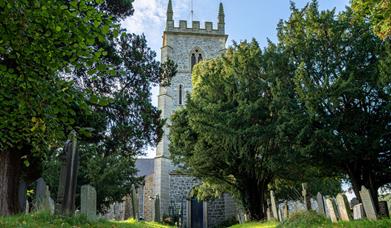
1. Standing at the entrance of the car park head straight across the road onto the pavement and back towards town. Follow the pavement on the right util you come to The Ivy House cafe, turn right here up towards the church. Enter the Church grounds and feel free to look around the church and the surrounding grounds. As you follow the path around head towards the gate at the other end.
2. Head almost straight over the road and down Churchbank past the Heale Hall and school. Keep following the road down until joining the B4386.
3. Turn right here and continue on the pavement past the fire station. Turn right onto Lymore Park lane. Look out for earthworks on your left which have a corrugated appearance. These are the remnants of ridge and furrow farming from the Middle Ages.
4. At the fingerpost by the lake, turn left towards the red house (Burnt House). Walk to the right of the house and fence, down to the woods. Cross a stile by the woods and continue with the stream on your right.
5. Cross the stream over another stile and follow the path until it meets the Offa’s Dyke path with the acorn sign, where you turn right over another stile. The path is straight, with woodlands on your right and fields to your left with Roundton Hill and Todleth Hill visible in the distance.
6. Cross over two more stiles until you meet a metalled road, turn right over the cattle grid and continue on it (ignoring the Offa’s Dyke path to your left). This access road takes you through Boardyhall Wood, past Lymore Lodge and farm buildings to the lake on your right. Remnants of the other lakes that once covered the area can be seen in the earthen banks around you.
7. Follow the bridleway to your left opposite and away from a large oak tree. This leads you back towards Montgomery. As you approach the B4385, veer right through wooden gates and back up into town
Book Tickets
Facilities
Routes
- Circular Route
Map & Directions
Road Directions
From the southern end of the Welshpool by-pass, take the A490 and right onto the B4388.
Accessible by Public Transport: Welshpool station is 9 miles away.


")

