To provide you with the best experience, cookies are used on this site. Learn more

To provide you with the best experience, cookies are used on this site. Learn more

To build your own Itinerary, click  to add an item to your Itinerary basket.
Already saved an Itinerary?


Call direct on:
Tel0300 065 3000
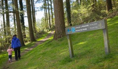 Cwm Rhaeadr Woodland | Walking Trails (NRW), LlandoverySix miles from Llandovery, this woodland and picnic area is in the peaceful Tywi valley. Glimpse the waterfall on the walking trail or explore the woodland on the accessible trail. Red-graded mountain bike trail for experienced riders.
This delightful reserve is set in the heart of Mid Wales near Ystradffin, Rhandirmwyn.…
Llyn Brianne is a spectacular reservoir at almost 300m (990ft) above sea level. It holds…
The Crychan & Halfway Forest is set in beautiful countryside nestling between the Brecon…
Abergwesyn Commons, on the southern edge of the Mid Wales Cambrian Mountains, is a wild…
The Usk Reservoir is a remote upland 280 acre reservoir surrounded by the Glasfynnedd…
Talley Woodlands overlook an historic village and ruined abbey in Carmarthenshire, 12…
Tregaron is one the oldest market towns in Wales, having received a royal charter in 1292…
The famous Brechfa Forest is managed by Natural Resources Wales for the benefit of…
Cors Caron is a vast wetland near Tregaron. The huge raised peat bogs and surrounding…
Denmark Farm is located in the heart of rural West Wales. Wildlife is at the heart of…
Rich with history, wildlife and culture, Strata Florida is the perfect place to visit.…
Strata Florida Abbey or Ystrad Fflur as it is known locally, is on the western edge of…
Coed y Bont is a community woodland situated on the edge of the village of…
Wales' best kept secret for 315 million years! The National Showcaves Centre for Wales…
Llyn Teifi is the largest of a group of six pools and reservoirs in Mid Wales in the…
A Welsh Garden with a Dutch History, Cae Hir is one of Wales' best loved private gardens.…

© Visit Mid Wales 2025. All Rights Reserved


