To provide you with the best experience, cookies are used on this site. Learn more

To provide you with the best experience, cookies are used on this site. Learn more

To build your own Itinerary, click  to add an item to your Itinerary basket.
Already saved an Itinerary?


You’re into tasting local delicacies and wandering small seaside towns or villages?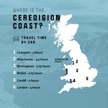 Tick.
Tick.
Walking a vast coastline and taking in the tranquil wildlife is more your thing? Great.
Adrenaline and big swells feature heavily in your vocabulary? Nice, we’re fluent.
Mid Wales has one of the largest and finest shorelines in the UK and the Wales Coast Path hugs the coast which means we have a whole lot to offer.
Its Mid Wales' authenticity that makes it a really big deal, and that means the hardest decision you’ll ever have to make while visiting is: “What’s next?”
Whatever you look for in a retreat, rest assured – this is where you’ll find it.
Aberystwyth is a University town and the largest town in Mid Wales, home to the National Library of Wales. For the best view of the town climb the steep Constitution Hill, either on foot or aboard the Aberystwyth Cliff Railway; the longest funicular electric railway in Britain.
New Quay is a picturesque town on the Mid Wales coast. From the harbour, you can see the famous Cardigan Bay dolphins most days in the summer.
Aberaeron's Georgian architecture was deemed so picturesque that it was featured on postage stamps. This fishing village is world famous for the quality of its honey (plus honey ice-cream and honey mustard produced locally) and also features prominently on the Dylan Thomas trail.
In Cardigan, the town's buildings are predominately Georgian and Victorian in style, many of which are in use as boutiques, traditional shops, inns and places to eat and drink. There is a wealth of local food producers in the surrounding area, and their produce is found on many menus throughout the town.
Aberystwyth is the largest town on the bay, with a university, seafront and castle. Aberaeron has a Georgian harbour and a growing food scene. New Quay is the best place for dolphin watching. Cardigan has a restored castle and the Teifi valley. Borth has a submerged forest and Ynyslas dunes.


Number of results: 164
, currently showing 141 to 160.
Aberystwyth
If you're looking for a short, yet picturesque walk along the coast, the Wales Coast Path from Aberystwyth to Borth is an ideal option. This 5-mile (8 km) section is a delightful path, albeit with one or two hills to conquer.

New Quay
New Quay Wales Music Festival is a local run music and arts festival taking place in the small fishing town of New Quay.


Aberaeron
5th section of the Ceredigion Coastal Path
Total distance 11.9km (7.4 miles)
Aberaeron to Aberarth 3.1km (1.9miles), grade/easy
Aberarth to Llanon 4.8km (3.0 miles), moderate-easy
Llanon to Llanrhystud 4.0km (2.5 miles), grade/easy
A 28km trail along designated cycle paths and quiet country lanes between the towns of Aberystwyth & Devils’ Bridge.
Cardigan
Join Illyria Theatre at Cardigan Castle for a magical outdoor performance of Pinocchio. Filled with adventure, humour, and memorable characters, this family-friendly retelling of the classic tale follows Pinocchio’s journey as he learns about…
Aberystwyth
Cancer Research UK’s Race for Life is a series of annual events raising money for research into all 200 types of cancer.
Cardigan
The Cardigan River & Food Festival is one of West Wales’ premier food and river celebrations, now in its mid-26th year.
Aberystwyth
Enjoy a 12 mile scenic steam journey on the railway before embarking on a guided walk through the breathtaking landscapes surrounding Devil's Bridge.
Aberystwyth
The Arts Centre can cater for events and conferences up to the capacity of 900 people.
Award winning Aberystwyth Arts Centre is Wales’ largest arts centre and recognised as a 'national flagship for the arts'.
New Quay
A visit to New Quay is all about sandy beaches that extend in an arc around the bay, the harbour where boat trips will take you dolphin spotting in Cardigan Bay, and the great Welsh poet, Dylan Thomas enjoyed a few pints in the local.
Cardigan - Borth
The Ceredigion Coast section of the Wales Coast Path providers the walker with glimpses of dolphins and porpoise, seals and a host of marine birds throughout the year around the majestic sweep of Cardigan Bay .
Aberystwyth
The railway station is the terminus of the Cambrian Line from Shrewsbury. Located close to the town centre, there is a taxi rank and bus station adjacent.

Lôn Teifi is part of National Route 82 between Aberystwyth and Fishguard.
Cardigan
Illyria Theatre presents As You Like It. This lively comedy follows Rosalind’s adventures in the Forest of Arden, where disguises, romance, and humour lead to unexpected discoveries about love and identity.
Borth
Start: Borth High Street
Grid Reference: SN 608 901
Distance: Walk A: 4.4 km – 2.7 miles
Walk B: 10.7 km – 6.6 miles
Grade: Easy
Terrain: Roads, firm tracks, sand and shingle
Maps: OS Explorer – OL 23 & 213
Cardigan
If you feel like ‘Walking on Sunshine’ this summer join us at Cardigan Castle – Eurovision song contest winner Katrina will perform on Saturday the 18th of July
Ceredigion
Borth is a charming coastal town in Mid Wales, part of the Dyfi Biosphere and the only UNESCO Biosphere reserve in Wales. With a Blue Flag Beach, excellent surfing, stunning natural surroundings, unique local legends, and a railway station on the…
Llanrhystud
6th section of the Ceredigion Coastal Path Llanrhystud to Aberystwyth
Total Distance 17km (10.6 miles) Grade - moderate/hard
Despite being challenging this section of Heritage Coast is dramatic, lonely and extremely worthwhile.
Aberystwyth
Constitution Hill rises dramatically 430 feet from the north end of Aberystwyth promenade. The views from the top are spectacular and on a clear day you can see Snowdon. Take the cliff railway to the summit or follow the coast path.
Llangrannog
Originally a hidden village above the old port, Llangrannog is now a popular beach and together with Cilborth immediately to the north, provides a favourite destination for families on days out, beach holidays and with surfers.

© Visit Mid Wales 2026. All Rights Reserved

