to add an item to your Itinerary basket.


Book Tickets Online
About
Offa’s Dyke Path is a 177 mile (285 Km) long walking route which was designated as a National Trail in 1971. Up to 65 feet wide and 8 feet deep, Offa’s Dyke is named after, and often follows, the spectacular Dyke King Offa ordered to be constructed in the 8th century, probably to divide his Kingdom of Mercia from rival kingdoms in what is now Wales and today the route roughly follows the current border between England and Wales.
The Trail passes through many different types of landscape. The upland stretches in the Brecon Beacons and Clwydian Range can be hard going in poor weather or visibility. The flattest stretch is the section which largely follows the River Severn and the Montgomeryshire Canal. Elsewhere it is largely a case of gentle ups and downs.
Buttington Bridge to Llanymymech Section
The Buttington Bridge to Llanymynech section of the Offa's Dyke National Trail starts at Buttington Bridge where you meet the River Severn, from where it is a short walk into Welshpool in the county of Powys (former counties of Montgomeryshire (Welshpool was the county town), Radnorshire and Brecknockshire).
This section is a transitional stage between the hills and almost flat throughout. The Trail follows stretches of the Montgomeryshire Canal and the River Severn before reaching the town of Llanymynech where the Wales – England border is the main street!
The main landmark viewed over the River Severn from the Trail is that of the Breidden Hills, with Rodney’s Pillar on its summit. Breidden Hill is a volcanic hill that rises some 1200 feet. On the top is Rodney’s Pillar - erected in 1781 by local landowners that supplied oak from their forests which was shipped down the Severn River to Bristol where Admiral Sir George Rodney’s fleet was built. A veteran of many campaigns, his fleet was used in the West Indies to defeat French and Spanish ambitions for Jamaica and the American War of Independence.
Parts of this section are prone to flooding during very wet periods so checking for Environment Agency flood warnings is advisable.
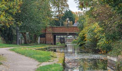
The Trail joins the Montgomery Canal for a number of stretches. The route takes you along the Canal's towpath, which serves as an interesting reminder of transportation methods from two centuries ago. Along the way, you'll encounter many charming locks and keeper's cottages. Additionally, there are several nature reserves developed along the banks of the canal that are home to a diverse range of wildlife.
The canal was originally used to transport lime to improve the farmland of the Severn Valley. While in Llanymynech, a visit to the heritage area with its Hoffman Kiln, the best preserved of its kind, is well worth it.
Book Tickets
Facilities
Routes
- Description of route - Buttington Bridge to Llanymynech
- Length of route (miles) - 11
Map & Directions
Road Directions
A458 from Shrewsbury.
Public Transport Directions
Mainline station at Welshpool.