to add an item to your Itinerary basket.


Book Tickets Online
About
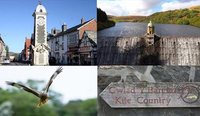
Rhayader and the Elan Valley is a great area to get off the beaten track. You'll find something for everyone from gentle relaxing walks including Town Trail, wildlife and nature trails to more challenging long distance routes for more experienced walkers. A few examples are listed below and further information is available from the Elan Valley Visitor Centre or the local Rhayder Information Centre
RHAYADER TOWN TRAIL
Beginning from the Smithfield Market this walk will take about one hour at a leisurely pace. It is accessible for wheelchairs and pushchairs although there is steep 50m climb at Waun Capel Parc
RHAYADER RIVERSIDE WALK
The Riverside Walk starts at the Car Park in Water Street where you will find an interpretative panel. Follow the river bank for views across the rover to Groe Park
THE ELAN VALLEY TRAIL
The Elan Valley Trail is a linear path following the line of the old Birmingham Corporation Railway. The trail starts in Cwmdauddwr, just west of Rhayader and finishes 13 km (8 miles) further up the Elan Valley at Craig Goch Dam.
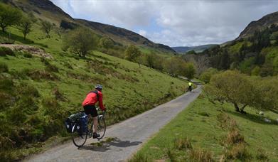
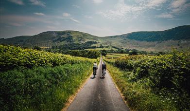
The trail is virtually flat and has self-closing gates, picnic sites and regular stopping points with seating where you can rest and enjoy the views. Following the line of the railway used in the building of the dams, the Elan Valley Trail is suitable for walkers, cyclists, horse riders and the less-able.
The start of the Trail is located just out of Cwmdauddwr, west of Rhayader along the B4518. Opposite the start is a small car park (grid reference SN 966677). The start is marked by a sculptural gateway by artist Reece Ingram. About ½ km along the Trail you reach the Radnorshire Wildlife Trust Reserve of Rhayader Tunnel.
Continue towards the Elan Estate for another 3.5 km where you reach a left turn at a road T- junction. From here you follow the road down the hill for 1/2km to the Elan Valley Visitor Centre, or cross the road and continue along the next section of the Trail.
The Trail continues for a further 9km up the Elan Valley to Craig Goch Dam. At 1km intervals you will see sculptural benches, created by artist Dominic Clare, the first of which is located just past Caban Coch Dam. Continue alongside the waters of Caban Coch Reservoir to Garreg Ddu.
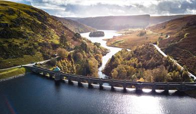
Continue along side the waters of Caban Coch Reservoir to Garreg Ddu. From here you may wish to cross the viaduct for a closer look at Nantgwyllt Church. Otherwise continue across the road past the Foel Tower. The Foel Tower is the point at which water is extracted from the reservoirs before stsrting its 120km/70mile journey to Birmingham by gravity.
Continue along Garreg Ddu Reservoir for 3km, cross the road and continue up the gradual incline up through the trees to the top of Pen y Garreg Dam. The track now levels out and passes alongside Pen y Garreg Reservoir.
About 1km along from Pen y Garreg Dam, you will pass through Devil’s Gulch. This cutting through the rock had to be blasted away and held up construction of the railway for 3 months.
GWASTEDYN CHURCH TRAIL
This circular 36 mile trail over an established pilgrimage route begins and ends in Rhayader and Cwmdeuddwr. Linking seven historic churches, the route uses mountain paths, lanes and old railway lines to guide you into the heart of our magnificent mountain, river and lake country.
To follow the Trail takes you into a world of history and literature derived from the world of the Celtic Saints, the Romans and Romano British, the Normans, the Welsh princes, the medieval monks through to the romantic poets and the Victorians.
Book Tickets
Facilities
Parking
- EV Charging - Dark Lane Car Park, Rhayader, LD6 5DD
Property Facilities
- Public toilets - Dark Lane Car Park, Rhayader, LD6 5DD
Map & Directions
Road Directions
By Car: The town of Rhayader is crossed by the main A470 (North/South) and A44 (East) roads. The Elan Valley is 3 miles from the town of Rhayader on an unclassified road leading from the B4518.
Elan Valley Car Park £2.50 car parking charge covers you for the whole of the Estate's car parks, all day. There are two electric charging points located at the Elan Valley Visitor Centre.
Public Transport Directions
The nearest railway station is Llandrindod Wells which is 14 miles away. The Elan Valley is connected by local public transport via Rhayader on request/pre-booking ONLY.
Public Transport Information: www.travelinecymru.wales