To provide you with the best experience, cookies are used on this site. Learn more

To provide you with the best experience, cookies are used on this site. Learn more

To build your own Itinerary, click  to add an item to your Itinerary basket.
Already saved an Itinerary?


Where Mid Wales meets North Wales. Where our places to stay have mountain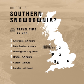 views, lakes on the doorstep, waterfalls within walking distance. You can find them here.
Snowdonia National Park is the largest National Park in Wales, with the highest mountain in England and Wales, and the largest natural lake in Wales.
Must See Attractions include Coed y Brenin, Britain's first purpose-built mountain bike centre. It is one of the sport's top destinations featuring work-class mountain bike trails, family walks, a cafe, cycle shop, all-ability play area and an easy access trail.
Portmeirion is situated on a private peninsula overlooking stunning coastal scenery, the Italian Riviera meets rural Wales with a riot of colour and architectural styles at Portmeirion Village. Built by Sir Clough Williams-Ellis, Portmeirion is now one of Wales’ most popular destinations.
Harlech Castle crowns a sheer rocky crag overlooking the dunes far below, the peaks of Snowdonia rising as a backdrop.
In the stunning UNESCO Dyfi Biosphere in Mid Wales, The Centre for Alternative Technology (CAT) is a world-renowned eco centre that demonstrates practical solutions for a sustainable future.
Visit one of our heritage railways in Southern Snowdonia. The Ffestiniog Railway is the oldest independent railway company in the world, established in 1832.
Southern Snowdonia Towns | Places to Stay | See & Do


Number of results: 268
, currently showing 241 to 260.
Pantperthog, Machynlleth
Start: Centre for Alternative Technology
(C.A.T) car park
Grid Reference: SH 754 044
Distance: 7.1 km – 4.4 miles
Grade: Moderate (some steep sections)
Terrain: Firm tracks, roads and open grassland
Maps: OS Explorer OL23 or 215

Aberdyfi | Aberdovey
This gentle four mile walk soon gets you up above Aberdyfi, enjoying fine views over the mouth of the Dyfi estuary and south towards Borth and Aberystwyth.
Starting place: Tourist Information Centre
Starting ref: SN 614959
Machynlleth Town Centre
This section of route 82 heads South towards Aberystwyth but the route is still under construction. Beyond Aberystwyth the route heads along the old railway line towards Tregaron and Lampeter. The route finishes in Fishguard.
Gwynedd
Neolithic tomb comprising two chambers of different phases, originally covered by a stone cairn.

Harlech
Llandanwg beach is just south of Harlech; the village is famous for its church which stands just a stone's throw from the sea.
Nr Corris
Abercorris Nature Reserve in southern Snowdonia is a three acre site of remnant broadleaved woodland on the steep east bank of Afon Deri combining the woodland habitat with that of the mountain stream below.
Nr Dolgellau
Cregennan Lakes in southern Snowdonia are owned by the National Trust and are a renowned and often photographed beauty spot. There are tremendous views of the Mawddach Estuary and Barmouth Bridge from near the lake.and the lakes are situated on the…
Fairbourne
Between Dolgellau and Tywyn off the A493, the village of Fairbourne has a sandy beach two miles long on the Cambrian Coast with the superb countryside of the Snowdonia National Park to the east.
Aberdyfi
Start: Snowdonia National Park Authority car park, Cwm Maethlon/Happy Valley
Grid Reference: SN 640 986
Distance: 5 km - 3.1 miles (shortcut 4 km – 2.5 miles)
Grade: Moderate
Terrain: Open moorland, firm tracks, fields and tarmac road.
Dyffryn Ardudwy
Dyffryn Ardudwy railway station is on the Cambrian Coast Line from Machynlleth to Pwllheli.
Machynlleth
This 35 mile circular route takes you on the A487 from Machynlleth via Corris towards Dolgellau and before turning off on the B4405 to Tywyn via the picturesque Talyllyn lake at the foot of Cadair Idris. Return to Machynlleth via Aberdyfi.
Dolgellau - Barmouth
The vast and sandy Mawddach estuary is one of Snowdonia National Park’s most remarkable areas. The area is designated a Site of Special Scientific Interest and a Special Area of Conservation due to its salt marsh and lowland peat habitats.
Fairbourne
Count Louis will return to celebrate its 100th birthday and will be joined by Ruislip Lido Rly’s Mad Bess
Llwyngwril
Llwyngwril railway station is on the Cambrian Coast line from Machynlleth to Pwllheli.
Gwynedd
Deep in the mountainous heart of mid Wales, nestling at the foot of Cadair Idris, lie the ruins of Castell y Bere. An atmospheric site, it is an outstanding example of a stronghold of the native Welsh princes.
near Barmouth
The spectacular Morfa Dyffryn Reserve stretches for about 4.5 miles along the coast of Cardigan Bay from Afon Ysgethin in the south to Afon Artro in the north.
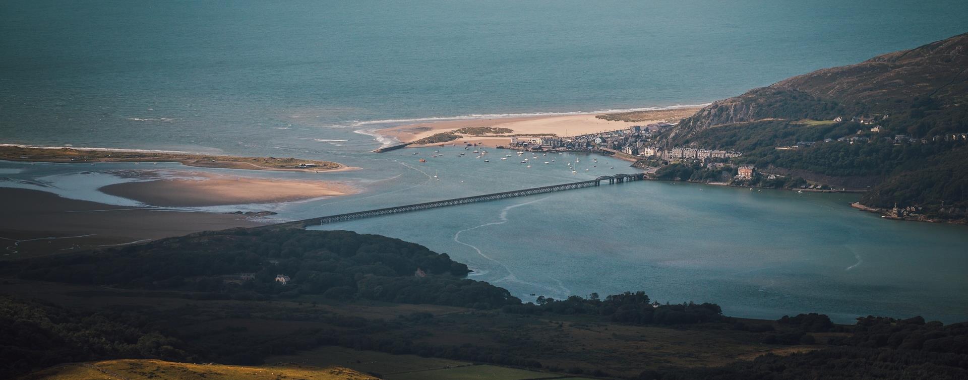
Barmouth
The Dinas Oleu Walk takes you from Barmouth town centre through the steep narrow winding streets of the Old Town and up to the top of the gorse-covered hill, known as Dinas Oleu (Citadel of Light).
Pontrhydfendigaid
At the heart of Pontrhydfendigaid - 'the bridge of the blessed ford' (known locally as ‘Bont’) is a narrow hump backed bridge across the river Teifi, whose source is about 5 miles away in the hills, at Teifi Pools.
Machynlleth
Start: NRW forest car park.
Turn R just before Aberllefenni village sign.
Grid Reference: SH 769 092
Distance: 8.4 km - 5.2 miles
Grade: Easy/Moderate
Maps: OS Explorer . OL23
Tywyn
The Awdry Extravaganza celebrates the life and work of Rev. Wilbert Awdry, creator of Thomas the Tank Engine.

© Visit Mid Wales 2024. All Rights Reserved

